| 
              
                | OWI SPEC |  
                |  |  
                |  |  
                |  |  
                |  |  
                |  |  
                |  |  
                | GROW-FINE |  
                |  |  
                |  |  
                |  |  
                |  |  
                |  |  
                |  |  
                |  |  
                |  |  
                |  |  
                |  |  
                |  |  
                |  |  
                |  |  
                |  |  
                | GROW |  
                |  |  
                |  |  
                |  |  
                |  |  
                |  |  
                | JIP |  
                |  |  
                |  |  
                |  |  
                |  |  
                |  |  
                |  |  
                |  |  
                |  |  
                |  |  
                |  |  
                |  |  
                |  |  
                |  |  
                |  |  
 | 
               
                |  |  |   
                | 
                     
                      |  
                           
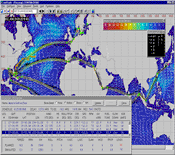
 In partnership with C-MAP's Integrated Maritime Suite 
                            (IMS) for vessel optimization and Oceanweather's 38+ 
                            year global wind and wave hindcast (GROW), 
                            TOWSIM is a tool to develop Trans-Ocean Criteria for 
                            transporting offshore structure on a barge, towing 
                            an FPSO, drill ship and other floating vessel.
 
                          Custom 
                            tailored modeling of the barge or self propelled ship 
                            are used to predict vessel speed performance and motion 
                            responses in wind and waves.38+ 
                            years of validated Global wind and wave hindcast database 
                            including tropical cyclones.Detailed 
                            wind, sea and swell information on a 0.5 degree grid.Simulates 
                            user specified route with various departures and monthly 
                            statistics. |  
                             
 |   
                      | 
 For 
                            more information on CMAP's IMS product please see 
                            http://commercialmarine.c-map.com/en/route-planning-and-fleet-management/ims 
                            
 
   A 
                            detailed TOWSIM report will include the following 
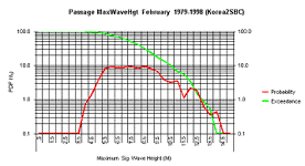
                            information based on various seasons and/or routes. Monthly 
                            Exceedance and Probability Density Maximum 
                            vessel motion responses, encountered environmental 
                            conditions, trip duration, and associated criteria 
                            for each simulated passage are compiled to show statistics 
                            including Monthly Exceedance, Probability Densities, 
                            and Cumulative and Exceedance Probabilities.  
                            
 |   
                      |  
                          Scatter 
                            Diagrams and Spectra 
 Conditions 
                            en route such as wind speed, direction, sea, swell 
                            height period and direction, vessel pitch, roll angles, 
                            vertical, lateral accelerations at various hourly 
                            intervals for each simulated passage are compiled 
                            to provide the following statistics: 
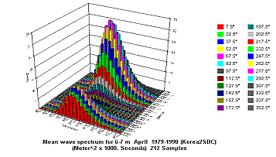
 
                           
                            Monthly Wind Speed vs. Wind Direction, Wind Speed 
                            vs. Significant Wave Height, Roll vs. Pitch Angles, 
                            Vertical vs. Lateral Accelerations, Significant Wave 
                            Height vs. Peak PeriodJoint 
                            probabilities along the route 
                            Mean directional wave spectra from sea and swell parameters 
                            are utilized for fatigue and long term response predictions 
                            along the route   |  |  |   
                |   For 
                    more information please contact oceanwx@oceanweather.com   |  |