In
2012, a 3-D HYCOM current hindcast was added. It contains
1-hourly water level, current speed and direction
with and without tide, salinity, and temperature information
at up to 30 levels most recently for the period September
1992 - June 2012.
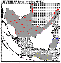
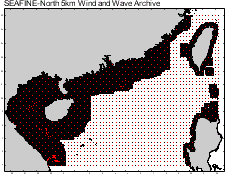
SEAFINE-NORTH
extends the domain (where the original SEAMOS/SUS/SOUP
grid exists) northward to ~27N on a 0.05 degree grid.
Major improvements to the techniques and modeling
of tropical systems have been made since SEAMOS was
first developed making it desirable to reanalyze the
top storms in the basin.
SEAFINE-NORTH contains winds and waves for the period
July 1956 - June 2015 on a high resolution grid comparable
to SEAFINE with reanalysis of the top tropical and
monsoon events within the period.
In 2021,
Oceanweather revisited this basin to update the hindcast
beyond 2015. This latest version, named SEAFINE-2, uses
the newer ECMWF ERA-5 wind forcings as the background source,
updated bathymetry, and a single 0.05 deg fine mesh grid
spanning the entire South China Sea including the Philippines
for the first time. Continuous 1-hour operational winds
and waves are archived at nearly 200,000 grid points starting
in 1979. Stronger tropical cyclones were subject to
analyst review before blending the tropical cyclone into the
background winds. A separate 15-minute archive was created
for the tropical cyclone periods as well. See the GROW-FINE China Seas
product page for more information including the grid layout.

- Time
series of wind and wave parameters in ASCII or OSMOSIS
format
- Return
period extremes for wind speed, wave height (significant,
maximum and crest) and wave period
- Operability
statistics expressed as monthly and annual frequency-of-occurence
tables and persistence/duration statistics
- Directional
wave spectra
- 3-D
HYCOM current hindcast to complement the wind and
wave hindcast