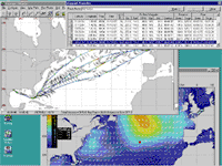
A
powerful optimization algorithm evaluates thousands of candidate
routes to find the fastest and most cost-effective routes for
user specified arrival times while satisfying the safe operating
criteria for motion, engine overload and hull stress limits.
VVOS includes the following:
Custom
tailored modeling of the ship's hull, engine and propeller
are used to predict vessel performance and hull response
in wind and waves
Passage
and Offshore Tow simulation using forecast or historical
weather
Monthly
sea state climatology based on past analysis data for passages
longer than 10 days
User
friendly graphical interface under the Microsoft Windows
operating system
Interfaces
with Integrated navigation and Electronic Chart Systems
Seakeeping Decision Support
A
sophisticated ship motion program interfaced with sensor
input recommends optimum speed/rpm and heading to reduce
risk of heavy weather damage. VVOS also:
Warns
of potentially dangerous events through continuous monitoring
and recording of ship motion, accelerations, SHP and RPM
Predicts
motion, slamming, bending moment, shear force, speed, power
and RPM under forecast or user input sea and swell conditions
Warns
of engine overload and propeller racing conditions
User
friendly intuitive interface to try many "what if"
scenarios
Custom
display for helicopter landing and other special applications
Proven
to lower life-cycle cost of hull and machinery
Shipboard Weather Station
Forecasts
from Oceanweather's forecast center are used as input into VVOS.
These quality controlled forecasts are verified with satellite
altimeter wind and wave measurements, buoy measurements
and ship observations. Features include:
High
resolution global wind and wave forecast with nested grid
for tropical storms and coastal regions
Three
wave trains are used to model sea and swell conditions
Separate
ocean regions downloadable by ships at sea 365 days a year
User
configurable size and type of projection for displaying
different weather products

 A
powerful optimization algorithm evaluates thousands of candidate
routes to find the fastest and most cost-effective routes for
user specified arrival times while satisfying the safe operating
criteria for motion, engine overload and hull stress limits.
VVOS includes the following:
A
powerful optimization algorithm evaluates thousands of candidate
routes to find the fastest and most cost-effective routes for
user specified arrival times while satisfying the safe operating
criteria for motion, engine overload and hull stress limits.
VVOS includes the following: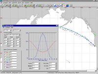 A
sophisticated ship motion program interfaced with sensor
input recommends optimum speed/rpm and heading to reduce
risk of heavy weather damage. VVOS also:
A
sophisticated ship motion program interfaced with sensor
input recommends optimum speed/rpm and heading to reduce
risk of heavy weather damage. VVOS also: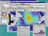 Forecasts
from Oceanweather's forecast center are used as input into VVOS.
These quality controlled forecasts are verified with satellite
altimeter wind and wave measurements, buoy measurements
and ship observations. Features include:
Forecasts
from Oceanweather's forecast center are used as input into VVOS.
These quality controlled forecasts are verified with satellite
altimeter wind and wave measurements, buoy measurements
and ship observations. Features include: