CYCLOPS: Tropical Cyclone Operational Prediction System
Offshore
operators in tropical basins have special requirements for
evacuation of personnel, orderly shutdown of operations
and other activities when faced with a tropical cyclone
threat.
Administrators
faced with evacuation decisions need two critical pieces of
data: (1) what are the expected conditions at the site
for the forecasted track/intensity and (2) how
bad could the conditions get when faced with a direct strike.
The answers to these questions ultimately drive the decision
making process and are exactly the kinds of questions CYCLOPS
was designed to answer.
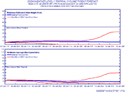
National
warning centers such as the Tropical Prediction Center and
the Joint Typhoon Warning Center routinely provide track
and intensity forecasts of tropical systems. Oceanweather
uses these parameters to drive its own tropical model and
to produce high-resolution wind and wave forecasts. Then,
the known characteristics of the track forecast errors are
used to develop an envelope of solutions that represent
the 90% probabilistic track error. The result is a simple-to-read
table and graph that represent the current forecast track
and 90% exceedence values of winds and waves at a location.
CYCLOPS
service is available for any tropical basin worldwide.

 Offshore
operators in tropical basins have special requirements for
evacuation of personnel, orderly shutdown of operations
and other activities when faced with a tropical cyclone
threat.
Offshore
operators in tropical basins have special requirements for
evacuation of personnel, orderly shutdown of operations
and other activities when faced with a tropical cyclone
threat.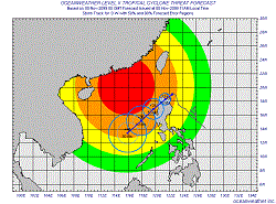 National
warning centers such as the Tropical Prediction Center and
the Joint Typhoon Warning Center routinely provide track
and intensity forecasts of tropical systems. Oceanweather
uses these parameters to drive its own tropical model and
to produce high-resolution wind and wave forecasts. Then,
the known characteristics of the track forecast errors are
used to develop an envelope of solutions that represent
the 90% probabilistic track error. The result is a simple-to-read
table and graph that represent the current forecast track
and 90% exceedence values of winds and waves at a location.
National
warning centers such as the Tropical Prediction Center and
the Joint Typhoon Warning Center routinely provide track
and intensity forecasts of tropical systems. Oceanweather
uses these parameters to drive its own tropical model and
to produce high-resolution wind and wave forecasts. Then,
the known characteristics of the track forecast errors are
used to develop an envelope of solutions that represent
the 90% probabilistic track error. The result is a simple-to-read
table and graph that represent the current forecast track
and 90% exceedence values of winds and waves at a location.